The province of Saskatchewan is situated in the centre of Canada, bounded by Alberta to the west, Manitoba to the east, the Northwest Territories to the north and the US to the south. It is the only Canadian province with entirely artificial boundaries.
Saskatchewan is one of the Prairie provinces with waving wheat fields, shimmering horizons and brilliant sunsets. Saskatchewan is named after a Plains Indian word "kisiskatchewan", meaning 'swiftly flowing river', which refers to the Saskatchewan River. If you haven't seen it with your very own eyes, it is hard to imagine how much space this province offers. Even though some consider the scenery monotonous, it is quite amazing to see such wide-open spaces, often without a tree in sight.
|
|
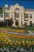
Saskatchewan is working hard to create province wide tourism and has much more to offer than many may believe. Tourists who stop to explore have been finding Saskatchewan to be a well kept secret. There are several great historical parks offering hands-on experiences of the Native Indian way of life. The Qu'Appelle Valley is a giant playground with beautiful resort villages, golf courses and provincial parks. Prince Albert National Park is one of Saskatchewan's most popular four-season destinations. Grassland National Park preserves the Killdeer Badlands and some spectacular sections of the Frenchman River Valley. The Athabasca Sand Dunes are among the most northerly major sand dunes in the world.
Although the southern region is mercilessly flat, the Cypress Hills in the southwest reach a height of 1,392 metres and makes it the highest point of land between Labrador and the Rocky Mountains, even higher than Banff, Alberta.
Saskatchewan has a lot to offer for outdoor enthusiasts. Fishing can keep you busy quite a while. If you wanted to fish all the lakes of the north, you would be busy each day for the next 270 years, considering you fished a different lake each day. There are 68 species of fish within the province's waters. The most widely distributed are northern pike and walleye. Trout anglers will find beautiful rainbow, brook and brown trout as well as Saskatchewan's only native trout, the laker. Many of the southern lakes offer excellent fishing, including Diefenbaker, Madge, Last Mountain and the lakes of the Qu'Appelle Valley.
|
|
Paddling is excellent in northern Saskatchewan with more than 50 mapped canoe routes. It is ranked as one of the great adventure destinations. The Churchill River rages across Saskatchewan, providing canoeists with some of the most exhilarating whitewater around. Clearwater River, a Canadian Heritage River, offers whitewater, waterfalls, limestone cliffs and majestic canyons along with historic attractions, such as Indian pictographs and the Methye Portage from the fur trading days. For those who prefer a more leisurely day or two of paddling will enjoy the Bagwa Route in Prince Albert National Park. For maps and further information on canoe tours in Saskatchewan, call 306-635-4420.
Prefer sailing? A number of Saskatchewan lakes were tailor-made for sailing. Head to Blackstrap, Last Mountain, Redberry, and Jackfish, or to Lake Diefenbaker which is known for its long stretches of ruggedly beautiful shoreline, protected bays and coves, and remote sandy beaches. For more information call the Saskatchewan Sailing Clubs Association in Saskatoon at 306-975-0833.
Saskatchewan in Figures
Saskatchewan has a population of about 1,013,035 people (2002).
Saskatchewan covers an area of 651,900 sq km, of which 12.5 per cent is fresh water..
The province of Saskatchewan is 1225 km long, 630 km wide across the south and 445 km across the north.
Regina is the capital of Saskatchewan with about 187,500 inhabitants
Saskatoon is the largest city of the province (Population 212,000)
About 76 per cent of the Saskatchewan's population lives in urban centres.
Cypress Hills - 1,392 m has the highest elevation in Saskatchewan.
Saskatchewan is Canada's "sunniest" province, averaging from 2,000 to 2,500 hours of sunshine annually.
The city of Estevan in the southeast leads the country with an average 2,540 sunshine-filled hours each year.
Important ethnic groups include British (16.5 %), German and Austrian (12.7 %), Aboriginal (6.8 %), Ukrainian (5.7 %), Canadian (3%), French (3%) and Scandinavian (2.4%).
Arrival
Most visitors arrive to Saskatchewan either by air via Regina or Saskatoon Airport or by car coming from Alberta or Manitoba.
Regina Airport is an ultra-modern airport with huge air cargo potential and connections to major North American cities, located 15-minutes from downtown. Getting to and from the airport is easiest by taxi. Many car rental agencies can be found at the airport.
For more information call (306) 761-7555
Saskatoon John G. Diefenbaker International Airport is located on an 827 hectare site in the northwest region of Saskatoon, 10 minutes from the city centre. Numerous daily arrivals and departures link Saskatoon with all Canadian, American and International points.
For more information call 306-975-8900
Saskatchewan is linked to Alberta by two major highways. Trans-Canada-Highway #1 leads from Calgary to the province's capital Regina and further east to Winnipeg, Manitoba. Highway 16 winds south-east from Edmonton to Saskatoon to meet Trans-Canada-Highway just west of Winnipeg.
Distances
Calgary, AB to Regina 764 km (474 mi)
Edmonton, AB to Regina 785 km (487 mi)
Winnipeg, MB to Regina 571 km (354 mi)
Saskatoon to Regina 259 km (160 mi)
|
|
Climate
Prairie summers are usually warm and dry with maximum temperatures reaching 40 º C. On average, Saskatchewan records the most summer sunshine of any Canadian province. Evening and night temperatures can be fairly cool. Winters are long and cold, beginning in November temperatures generally remain below the freezing point. Nevertheless, brilliant winter sunshine tends to moderate the effect of temperatures. Mild spring weather usually begins by April.
Means of payment
Besides the most common credit cards (Visa, Master Card and American Express) you might consider carrying some Traveler's Cheques in small denominations. Those are generally accepted like cash and have the advantage of being insured.
However you should always carry some cash, especially if you intend to push forward to more rural areas. Here cash is the only thing that counts as most of the small shops do not have the equipment to accept credit cards. You should not bring German Marks in order to pay your bills.
Prices
All prices are generally subject to applicable taxes, which might be uncommon for European travelers. Taxes are added when you pay. Usually you have to pay 7 per cent taxes (GST Goods and Service Tax) and 6 per cent (PST Provincial Sales Tax).
Waiters in a restaurant generally require a tip, which is added to the bill's total as this is sometimes the only pay they receive. It is up to you, how much you leave, but 10-15 per cent is fairly common. Usually you leave the tip on the table as you go. Tip is also given to cabbies, hairdressers, barbers, hotel attendants and bellhops.
We recommend saving all receipts, as tourists who have their place of residence outside of Canada might be eligible for tax refund. However, this only applies for amounts over CAN $50,00 per receipt (except accommodation receipt where no minimum amount applies) and a minimum of CAN $200,00 in total. Not eligible for tax refund are bills paid for gas or transportation. In any case it might be worthwhile to save receipts for accommodations or larger purchases that are exported. The application for tax refund can be found at the website address shown below. You can file your application up to six months after you have left the country and has to be in writing. A refund cheque will than be mailed to your home address. If you came by plane you are required to send your bording pass with your application. Receipts for goods have to be validated by Canada Customs as you leave Canada.
For further information visit
Visitor Tax Refund.
National Parks
Grasslands National Park
Location: The park is separated in two blocks, with the West Block in Frenchman River Valley and the East Block in the Killdeer Badlands.
Grasslands National Park is the first national park of Canada to preserve a portion of the mixed prairie grasslands. The park will eventually have a total size of 906.4 sq km. It is located between Val Marie and Killdear, south of Swift Current and west of Assiniboia. The park protects an unique flora and fauna, including Canada's only black-tailed prairie dogs and other rare reptiles and amphibians that are mainly spotted along the Frenchman River Valley.
For more information call (306) 298-2257
Prince Albert National Park
Location: Approx. 60 km north of the city of Prince Albert.
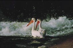
Prince Alberta National Park is located 200 km north of Saskatoon and protects part of the northern coniferous forest, home to elk, moose, deer, wolves and caribou. The 3,874 sq km park protects Canada's second largest white pelican colony at Lavellee Lake, as well as a wild herd of bison. The park offers great hiking trails and canoeing routes.
For more information call (306) 663-4522
Provincial Parks
Cypress Hills Provincial Park 
Location: 28 km south of Maple Creek or 164 km southwest of Swift Current.
Cypress Hills Provincial Park is situated on the border of southern Saskatchewan and Alberta and is Canada's first interprovincial park. With hills up to 1,400 metres it marks the highest elevation between Labrador and the Rockies. This scenic area offer small lakes, streams and green hills with lodgepole pine that is unique to Sasakatchewan. Other attractions include the Conglomorate Cliffs in the West Block, a beach, golf course and mini-golf, nature and hiking trails.
For more information call (306) 662-5411
Historic Sites
Batoche National Historic Site
Location: 88 km northeast of Saskatoon
Batoche displays the remains of a Metis community on the banks of the South Saskatchewan River. During the North West Rebellion 1885 the scene of the last battle took place here. Today visitors can see several buildings that have been restored. The church and rectory are the only buildings standing from 1885. The site showcases the lifestyle of the Metis between 1860 and 1900. The visitor reception center shows the events of the battle and the Metis social and economic life.
For more information call (306) 423-6227
Fort Walsh National Historic Site
Location: As part of Cypress Hills Interprovincial Park it is located 55 km southwest of Maple Creek
Fort Walsh, located in the Cypress Hills is a former North Mounted Police / Royal Canadian Mounted Police post. Named after Inspector James Walsh, the police post was constructed in 1875. Today guided tours of the fort's building bring the rich history alive. See the Fort Walsh townsite, two cemeteries and a reconstructed whiskey trading post at this National Historic Park.
For more information call (306) 662-2645
History
The region today known as Saskatchewan has been inhabited by Native Indians of three distinct language groups for at least 10,000 years. Most prominent among them were the Chippewa, Cree and Assiniboine. Each of the three main language groups occupied approximately a third of the area.
The first European explorers arrived in the late 17th century, mainly for one single reason - fur trade. In 1690, Henry Kelsey of the Hudson's Bay Company came to Saskatchewan. The Native Indians aided the first explorers and traded furs.
|

|
Native people who were in the trade often became increasingly dependent on one particular fort or post. By the late 18th century such settlements dotted the fur-bearing areas.
In 1870, Rupert's Land (which includes present day Saskatchewan) was sold to Canada and renamed the Northwest Territories. The Dominions Lands Act of 1872 offered free homesteads to settlers in order to stimulate immigration. In 1882, the Canadian Pacific Railway reached Regina and one year later, in 1883 Regina became the capital of the Northwest Territories. The first elected Legislative Assembly of the Northwest Territories came into power in 1888.
In 1905, the province of Saskatchewan was formed. All efforts to encourage immigration shows dramatically in the statistics. In 1885 the population of the area was 32,097, of whom half were British and 44 per cent were native. In 1911, the population had mushroomed to 492,432, of which half was still British, but the native people had dropped to 2.4 per cent.
The Great Depression of the 1930s brought widespread hardship to Saskatchewan. After WW II the significance of wheat production increased. Farms became bigger and bigger in order to be competitive. Between 1961 and 1962 Saskatchewan became the first Canadian province that introduces Medicare which in return lead to the Saskatchewan Doctor's Strike in 1962.
Today Saskatchewan produces 54% of the wheat grown in Canada. Besides Agriculture, service-based sectors such as finance, insurance and real estate are important to Saskatchewan's economy.
|


